Revisando uma Observação
[image]
Revisando uma Observação
Para CoMapeo Mobile v8
O que é uma Observação?
Uma Observação é um dado vinculado a uma categoria e a um único conjunto de coordenadas, representando um ponto no mapa. Ela pode conter várias informações para ajudar a contar uma história ou servir como evidência. As observações são coletadas no CoMapeo e constituem as principais fontes de dados, juntamente com as trilhas.
É possível abrir uma observação para revisão selecionando-a no  Mapa ou a partir da
  Lista de Observações.
Porque revisar uma Observação?
Revise uma observação para ver todas as informações que foram registradas com ela. A revisão pode ajudar a confirmar detalhes, verificar evidências e garantir que os dados estejam completos e precisos.
Quais informações constam em uma Observação?
Informações adicionadas automaticamente
Essas informações provêm dos sensores do dispositivo, das configurações do dispositivo e do uso do aplicativo, e não podem ser modificadas.
 Coordenadas e precisão
A localização da observação é exibida em uma pré-visualização do mapa. Esse costuma ser o detalhe mais importante a ser incluído ao falar sobre ou compartilhar uma observação, especialmente com autoridades e especialistas em SIG.
Coordenadas e precisão
A localização da observação é exibida em uma pré-visualização do mapa. Esse costuma ser o detalhe mais importante a ser incluído ao falar sobre ou compartilhar uma observação, especialmente com autoridades e especialistas em SIG.
Carimbo de data e hora
Essas informações provêm das configurações do sistema do dispositivo, no momento em que a observação foi coletada.
Metadados da observação
Trata-se de metadados associados às coordenadas registradas. Quando o GPS está ligado, esses metadados são capturados diretamente dos sensores e adicionam informações técnicas que podem ser de interesse para quem estiver realizando uma análise jurídica de uma observação. Há uma tela dedicada para exibir essas informações.
Trilha correspondente
Se a observação foi coletada enquanto uma trilha estava sendo gravada, o identificador de trilha também aparecerá.
Informações adicionadas manualmente
-
Nome e ícone da categoria
-
Descrição Notas adicionadas à área de texto
-
Detalhes Respostas do formulário Detalhes (se preenchido), que inclui campos de texto ou perguntas estruturadas associadas à categoria escolhida.
Verifique se as informações adicionadas descrevem corretamente o que foi observado. Se for necessário revisar ou esclarecer alguma coisa, é possível editá-las.
Acesse: 🔗 Editando um Observação
Mídia
Se forem adicionadas fotos ou arquivos de áudio a uma observação, eles serão automaticamente anexados a ela.
Miniaturas e visualizações de fotos
Todas as miniaturas das fotos tiradas serão exibidas em um carrossel horizontal.
Metadados das fotos
Uma tela que exibe os metadados associados a uma foto tirada com o CoMapeo.
Miniaturas e reprodução de áudio
Uma miniatura de áudio será exibida para cada gravação.
Validação de dados no CoMapeo
É importante poder confiar nos dados, na sua origem e na garantia de que não foram adulterados, a fim de construir confiança nas ferramentas e nas metodologias de coleta de dados. Isso também pode ser fundamental se os dados forem admitidos em processos judiciais; nesse caso, as evidências devem ser rastreáveis e verificáveis, o que significa que você deve ser capaz de confirmar como, quando e onde os dados foram coletados.
Uma observação validada pelo CoMapeo possui coordenadas GPS e fotos registradas usando o CoMapeo, utilizadas como meio de reforçar sua prova. Para isso, o CoMapeo requer permissões relacionadas à localização e ao uso da câmera do dispositivo. Sem essas duas permissões, o CoMapeo ainda é capaz de coletar dados por meio de opções de entrada manual, mas eles são marcados como observações não validadas, pois o CoMapeo não pode garantir que tenham sido inseridos corretamente.
[image]
Metadados de observação exibidos no CoMapeo sempre incluirão data e hora, coordenadas GPS, latitude e longitude
 Os metadados validados também exibirão precisão, altitude, precisão da altitude e velocidade.
 Os metadados não validados exibirão “ Esses dados foram inseridos manualmente”, para garantir que fique claro que as coordenadas provêm de uma inserção manual, e não do GPS automático e verificável do telefone.
👉🏽 Mais: Se a inserção manual de coordenadas foi usada ao salvar, a maioria dos metadados de GPS não estará disponível e haverá uma indicação de que a observação não está validada
👉🏽 Dica: Para compartilhar os metadados da observação com alguém que esteja auxiliando sua equipe, use  Compartilhar. Escolha entre E-mail e WhatsApp para abrir um rascunho de mensagem formatado, pronto para enviar.
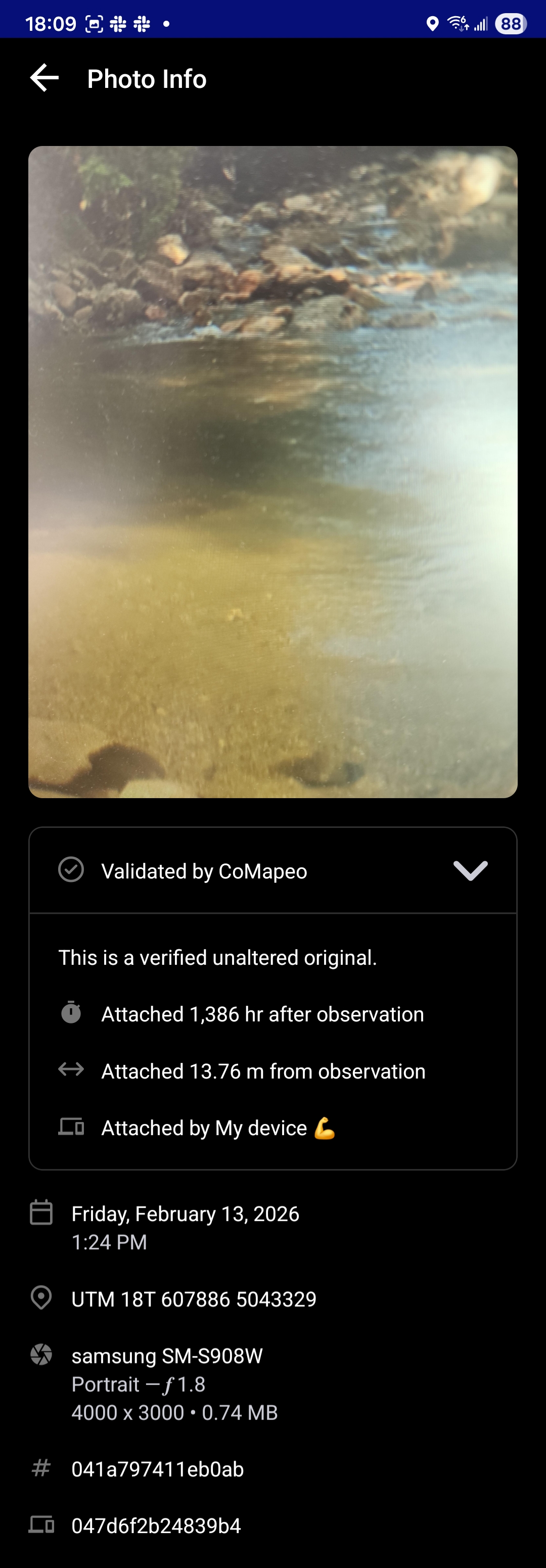
Os metadados da foto são informações capturadas por um smartphone e são específicas para cada foto tirada. Eles são exibidos abaixo da foto.
Se houver dúvida sobre a validade de uma foto em uma observação, os metadados da foto podem ser incluídos como prova. Esses metadados incluem:
-
Data e hora
-
Coordenadas GPS da fotografia
-
Metadados do dispositivo: tipo de dispositivo, detalhes da câmera, incluindo abertura, e tamanho da foto
-
ID da observação
-
ID do dispositivo
[image]
Abrir  Validado pelo CoMapeo para visualizar detalhes adicionais que indicam a proximidade, em tempo e distância, entre o momento em que a foto foi tirada e o momento em que a observação foi salva.
[image]
Para capturar todas as informações disponíveis em uma única imagem, use a opção,  e role para baixo, que aparece temporariamente após fazer uma captura de tela.
Mais ações disponíveis
 Editar uma observação
 Deletar uma observação
Compartilhar uma observação
Conteúdo relacionado
Acesse 🔗 Editando uma observação
Ir para 🔗 Compartilhamento de uma única observação e metadados
Ir para 🔗 Solução de problemas: Observações e trilhas
Ir para 🔗 Solução: Verificar permissões do aplicativo
Está tendo problemas?
Acesse 🔗Solução de problemas: Observações e trilhas